Sunday Screening: Lakota Nation vs United States @ The Yard, 4 Hanna Lane

Beacon City Council Member Paloma Wake has a personal passion for land justice, and is using her platform to promote the screening of Lakota Nation vs The United States. The screening is at The Yard, 4 Hanna Lane. It is co-presented by Paloma Wake and Story Screen. The Yard is providing the space. All proceeds go to First People’s Fund. First Peoples Fund is a Native-led non-profit that provides direct funding, resources, and professional development to Native American, Native Hawaiian, and Alaska Native artists, culture bearers, and Community Development Financial Institutions (CDFI).

Paloma submitted an explication for the screening which ALBB has published below:

“I am writing as a Councilmember and Beacon citizen. This Sunday at 5pm, I am co-hosting a screening of a documentary - Lakota Nation vs. United States - in collaboration with Story Screen and the Yard. Below is my reasoning on why this consideration of Mount Rushmore is relevant to the Highlands regionally.

“This month is Native American Heritage Month. As a federal designation, it encourages us to observe an Indigenous past, but rarely does that understanding extend to the present moment and acknowledge the ongoing lives, communities, and foundational sovereignty of Indigenous people and tribes.

“Lakota Nation vs. the United States, screening at 5pm on Nov 12, with StoryScreen, at The Yard, is the contemporary story of the Lakota, Dakota, and Nakota people and their struggle to reclaim the Black Hills of South Dakota, or what is commonly known as the location of ‘Mount Rushmore,’ contextualizing the violent formation of this so-called American monument. My experience of seeing this film for the first time was one of both profound sorrow and a profound opening toward collective liberation through a structural understanding of the present.

“In our small city, formed in 1913 and experiencing our own waves of change and displacement through gentrification, it is easy to feel starkly removed from a time when our river [the Hudson River] was known as Mahicannituck, the river that flows both ways. Hopefully this screening will support an ongoing community conversation about Indigeneity with the necessary context around the apparatus of settler colonialism, connecting an Indigenous past to our local Indigenous present and the possibilities the present holds for a beautiful future.”

Call For Vendors: Hudson River Maritime Museum: Celebration Of Woodworking

The Hudson River Maritime Museum is seeking craft vendors who work in wood for our first ever, “Celebration of Woodworking”. The event will take place on Saturday October 1st & Sunday October 2nd from 10AM–5PM on the grounds of the Hudson River Maritime Museum at 50 Rondout Landing, Kingston, NY 12401.
The celebration will include dozens of artisans working in wood and will feature a display of craft work from friends and members of the Mid-Hudson Woodworkers and a fine furniture exhibition showcasing the work of the Hudson Valley Furniture Makers. We will have numerous demonstrations where artists and craftsmen will share their knowledge and skills with the public.

Requirements: Vendors must be able to participate both days of the event. There is no fee to participate as a vendor, however we ask that 10% of sales be donated back to the museum to offset our operational costs.We are prioritizing vendors who sell handmade, wooden arts and crafts, as well as wood adjacent suppliers of both tools and live edge slabs. We also welcome other traditional and handmade crafts born from natural materials.

Those interested in signing up should fill out the vendor form available on the Hudson River Maritime Museum's website at www.hrmm.org/wwf-vendors.

More Information >

Clearwater Demands Swift Formation of Decommissioning Oversight Board For Soon To Be Holtec's Indian Point

clearwater seal-med.jpg

Hudson River Sloop Clearwater, launched in 1969 by legendary folk singer and activist Pete Seeger, Hudson River Sloop Clearwater has been at the forefront of the environmental movement as a champion of the Hudson River. Clearwater has been one of the leading organizations advocating for and monitoring the closing of Indian Point, which is entering into the decommissioning phase.

Regarding the sale, Governor Andrew Cuomo stated: "As Governor and previously as Attorney General, I have been deeply concerned with the safety of the Indian Point nuclear power facility given its proximity to some of the most densely populated areas in the nation. This is a win for the health and safety of New Yorkers, and the protection of our environment."

The sale of Indian Point to Holtec comes with a number of requirements, some of which are reported on at lohud. New York State’s Department of Public Service stated that an Indian Point Nuclear Decommissioning Oversight Board would be formed as part of the deal. According to reporting, Holtec, which is based in New Jersey, “wants to build an interim underground repository in the New Mexico desert for the 83,000 metric tons of nuclear waste stored at power plants across the U.S.”

To keep the pressure on the Decommissioning Board, Clearwater issued the following press release on Friday, May 21, 2021:

###

The recent announcement that the New York State Public Service Commission (PSC) approved the transfer of Indian Point’s licenses to Holtec International makes it urgent that the Commission convene a Decommissioning Oversight Board (DOB) immediately to review the company’s decommissioning plans.

The DOB should be comprised of all State agencies with jurisdiction over various aspects of decommissioning, together with independent scientists and experts in relevant fields, and a diverse group of representatives of affected communities, including environmental justice communities, environmental and citizens’ groups, business, labor, and first responders.

It’s important for the DOB to meet now, with its first order of business being to review Holtec's proposed Post-Shutdown Activities Report – their actual plan for:

  • Decommissioning

  • Site remediation

  • Radioactive waste management.

The plan is deficient in many respects and the DOB will need to get ahead of the many thorny problems that Holtec’s approach raises. Board members must have adequate time to study these issues thoroughly, and the DOB must submit its recommendations before PSC takes any action on it.

The PSC approved the license transfer subject to an agreement jointly negotiated by the state of New York, environmental organizations, Entergy (the former license holder) and Holtec.

Clearwater opposed the license transfer given Holtec’s problematic track record and lack of qualifications. While the joint agreement improves the prospects for a financially and environmentally responsible decommissioning process, it fails to adequately address many of our questions and concerns about Holtec’s plans. These include

  • Removal of spent fuel from the fuel pools less than 3 years before it has cooled sufficiently to move (especially high burn-up fuel, which requires 7 or more years of cooling)

  • The lack of rigorous onsite and offsite radiation monitoring needed to protect workers and the surrounding community

  • Superficial remediation of soils contaminated with radioactivity

  • No remediation of radioactivity leaking into the groundwater and the Hudson

  • Serious quality assurance, performance and safety problems with Holtec’s dry storage system for spent fuel

  • Holtec’s intention to ship high-level radioactive waste (which may include highly irradiated spent fuel) by barge down the Hudson, past New York City, to its consolidated interim storage facilities in New Mexico.

These and other issues related to Indian Point decommissioning raise serious safety concerns calling for diligent examination by the DOB. At the federal level, Nuclear Regulatory Commission oversight has been extremely lax, granting exemptions on request and effectively rubber stamping whatever Holtec proposed whether or not it violated existing regulation, or in some cases, existing law. These important issues need review by the DOB before Holtec resolves them on its own terms. We call on the PSC to empanel the DOB now and convene its first meeting quickly.

###

Take A Walk: New Pavilion Is Pleasant At Long Dock Park Along Hudson River In Beacon

pavilion-pleasant-long-dock-MAIN.png
long dock pavilion 1.jpg

In these gray days, it is important to get out of the house and take a walk. The new pavilion at Long Dock Park, a park by Scenic Hudson that began construction in 2017, is quite pleasant. The city’s historic gateway known as Long Wharf (constructed in 1815), this area used to be a drop-off point for cargo and passengers when Beacon and Newburgh relied upon manufacturing and the Hudson River as an economic waterway, according to signage at the park. The wharf used to have buildings, and then it became a dumping ground for industrial debris.

Today, it is a park for your enjoyment, featuring paved walkways, picnic tables and benches. Parking is available near the Metro-North train station, but is slim. In the summer, food trucks may be out and about. Scenic Hudson is taking applications for food trucks, which you can learn about here. See Scenic Hudson’s website for more information.

Exhibit of the Newburgh-Beacon Ferry Now Open - But First, Did You Take the Ferry Yet?

PLANNING FOR THE NEWBURGH FERRY EXHIBIT:
“This Way to the Ferry” Exhibit
Sundays 1-4 pm, through Dec. 31, 2016
$5 suggested donation
The Crawford House
189 Montgomery Street, Newburgh
845-561-2585; www.newburghhistoricalsociety.com

Many locals are likely aware of the cute blue and white ferry that chugs back and forth between Beacon and Newburgh multiple times each weekday. It's the official Newburgh-Beacon Ferry that roared back to life in 2005 after being taken out of the water when the Newburgh-Beacon bridge was built, and it is in the spotlight right now at the Newburgh Historical Society, who has the ferry's history on display at their headquarters at The Crawford House.

The Newburgh-Beacon Ferry as it approaches the Beacon dock from Newburgh. Photo Credit: Katie Hellmuth Martin

Most of the ferry riders are commuters from the west side of the Hudson River who have opted out of driving to New York City. Instead of driving over the bridge and trying to snag a coveted parking spot at the Beacon Metro-North train station, they hop on the ferry and arrive on the Beacon side, just steps from the local and express trains that will whisk them into New York City for work.

Any seat on the ferry has a view. The upper deck will get you unobstructed views of rolling hills and mountains. Photo Credit: Katie Hellmuth Martin

Still, savvy adventure-seekers are also discovering that the quick river jaunt (it’s about six to eight minutes) makes for a fun and affordable outing. Whether it’s a romantic rendezvous, capped off with cocktails on the Newburgh waterfront, or just a breezy boat ride with the kids, taking the ferry is a cool way to explore the region. 

The boarding dock on the Newburgh side.
Photo Credit: Katie Hellmuth Martin

A one-way fare for an adult is an easy $1.75, and kids under 5 ride for free. Children ages 6 to 11 as well as seniors 62 and older are only $1. The last trip from Newburgh to Beacon is around 8:20pm (always check the train schedule), so plan for an early night if hitting the Newburgh waterfront.

A ferrygoer, verifying the last ferry time, making sure to not miss the boat.
Photo Credit: Katie Hellmuth Martin

The Newburgh-Beacon Ferry runs on the weekdays only, so this is one trip you want to plan during the week. Keep in mind, however, that the ferry schedule is related to the peak-train schedule. The last ferry of the morning/day departs Newburgh at 8:04am, and then pauses for the day. The ferry starts up again with a departure out of Beacon at 5:42pm, and the last ferry returning from Newburgh at 8:24pm. Perhaps if the NY Waterway knew that more passengers wanted to ride the ferry during the day, they would expand their schedule (let them know here). Can you imagine, avoiding all of that bridge traffic to get to Newburgh, and enjoying an easy, breezy ride on the water for six minutes of relaxation? Don't believe me? Watch this video footage from our investigation (and wave to the captain):

“Whenever somebody comes to visit, the first thing that I do is take them down to the ferry,” says Mary McTamaney, the Newburgh City historian. “People are always amazed at how beautiful it is here and they get to see the scope of the river and Newburgh, perched up on the hill.”

The current ferry began service in October 2005, mainly to deal with the overcrowding at the Beacon train station parking lot. But the Newburgh-Beacon ferry actually has a long and storied history as one of the first, and longest-lasting, ferry routes in the country. First established with a charter from King George II in 1743, ferry service continued for 220 years until 1963, when the completion of the Newburgh-Beacon bridge made the ferry obsolete. ... Or so people thought.

Now, the new exhibit at the Crawford House Historical Museum in Newburgh uses photos, paintings, documents, videos, and other memorabilia to bring to life the story of the ferries that were such an integral part of transforming both Newburgh and Beacon into bustling industrial hubs.

What You'll Find at the Exhibit

The one-room exhibit, which is jointly sponsored by the Historical Society of the Newburgh Bay and the Highlands as well as the Beacon Historical Society, covers a lot of ground. It begins with the early days when the first ferries were powered by oars and then horses. Even George Washington and his troops rode the ferries frequently during the War of Independence!

But the bulk of the exhibit focuses on the early part of the 20th century, with intriguing photos of the three main ferry boats of this era: the Orange, the Dutchess, and the Beacon, all of which could carry up to 30 cars (the current ferry only transports people).

Photo Credit: NewburGh historical Society

The Dutchess ferry, carrying cars
Photo Credit: NewburGh historical Society

By the early part of the 20th century, both Newburgh and Beacon had bustling waterfronts. Situated halfway between New York City and Albany, Newburgh was a transportation hub on the river and had dozens of waterside factories producing everything from bricks to lawnmowers to ships. Both the Dutchess and the Orange were built in a Newburgh shipyard.  Workers crisscrossed the river via the ferries constantly — either to work in Newburgh or in one of the many Beacon factories that produced hats, bricks, and other wares.

The Ferry at Fishkill Landing. Photo Credit: Newburgh historical Society

The ferry was also a popular river crossing for travelers in the Northeast, as well a social outlet for people of all ages. “Teenagers, families, everybody loved to ride the ferry,” says McTamaney.

The boarding dock today near Long Dock on the Beacon side.Photo Credit: Katie Hellmuth Martin

The boarding dock today near Long Dock on the Beacon side.
Photo Credit: Katie Hellmuth Martin

The rose-lined walking path to the boarding dock on the Newburgh side.
Photo Credit: Katie Hellmuth Martin

The exhibit highlights lots of fun facts. When the Dutchess made its maiden voyage in 1910, there were separate entrances for men and women. Fares in 1953? Car: 60 cents. Large truck: $2.50. Pedestrians, bikes, baby carriage: 15 cents. By the 1950s, the ferries were running 24 hours a day, and one man recalls spending the entire night in the middle of the river when the Orange became encased in ice: “The boat departed the Newburgh slip at 11:30 pm … Five minutes later and close to mid-stream we really slammed into something which gave us a sudden jolt. We couldn’t see too well but the ice seemed to have piled up almost level with some of the windows.”  

Photo Credit: Newburgh Historical Society

Photo Credit: Newburgh Historical Society

Several photos and newspaper articles highlight the historic last day of ferry service: November 3, 1963 — one day after the opening of the Newburgh-Beacon bridge. The Dutchess and the Orange famously saluted each other mid-river on their final run. Captain William Atkins had been a ferry pilot for 41 years and recalls his last trip: “Twenty cars and a handful of passengers, many intent only on getting to Beacon, rode the Dutchess. The ferry’s smoke blew toward the Dutchess County shore. The slip rumbled as the engines started and the boat’s whistle sent up a forlorn goodbye to Newburgh.” The closure of the ferry is reminiscent of how The Little Red Lighthouse felt when the bridge got built above it, but this fear of becoming obsolete became a reality for decades. The resurgence of the ferry since 2005 has corrected that, thanks to the demand from commuters, and perhaps now people seeking an easier way to get to Newburgh than by car. Who knows, maybe with enough requests it will open on the weekend, or even return to running 24 hours a day!

In addition to the exhibit, the Crawford House itself is a must-see. This grand 1830 Neoclassical home simply oozes with historic (albeit musty) charm, featuring stunning river views and an impressive collection of Hudson River School paintings. It was built for Captain David Crawford, a maritime entrepreneur, who played a key role in turning Newburgh into a major shipping and industrial city. Architectural highlights include 40-foot iconic columns, front and rear Palladian windows, and exquisite woodcarvings throughout. In 1958, the Historical Society of Newburgh Bay and the Highlands purchased the house to prevent its demolition for a planned parking lot.

One kink in the perfect planning of going to the ferry exhibit: Visitors cannot take the ferry itself there, as the ferry only runs on weekdays, and this exhibit is open on Sundays from 1 to 4pm until December 31, 2016.

3 Comments

Olivia Abel

Olivia Abel is a longtime magazine editor and writer. Most recently, she spent a decade as the Editor in Chief of Hudson Valley Magazine, but she’s also written for People, The New York Times and many other publications. Olivia loves living in a town that has its very own eponymous mountain and although she never lived up to her public claim that she would climb said mountain every morning before work, she still loves exploring from one side of Beacon to the other. She is obsessed with local history and we’re happy that she’s hung up her editor’s hat (for now) and is writing for us. 

Denning's Point Hike: Walking The Rise & Fall of American Grandeur During the Industrial Revolution to the Jazz Age

Look at the bald eagle perched above you. The Wiccappee Indians saw them too. Stand on the clay and rock of the beach and watch the tide, George Washington and Alexander Hamilton did as well. Tucked away and easy to bypass, Denning's Point is as filled with as much history as it is with dense, diverse nature. Take in the breathtaking scenery and terrain of this 1.2 mile circuit trail, and take your time to inhale the vast history of it as well.

Denning's Point

The Nuts and Bolts of the Denning's Point Hike

You can park in the parking lot off of Denning's Avenue and take the little connector dirt road to the overpass going over the railroad and onto the point. You can also access the trail via the Madame Brett connectors or the Klara Sauer Trail. The point is actually a peninsula that juts out into the Hudson River, and is the northern-most point of the Hudson Highlands state park. It’s a flat hike that is full of native and invasive species of flora and fauna. The most common of these invasive include water chestnut, which blankets huge swaths of the river around the point, buckthorn, Asiatic bittersweet and swallowwart. You’ll also find, as you pass several old abandoned buildings, a multitude of tree species from maples to cherry and apple, as well as shrubs of honeysuckle, sumac and tastier varieties like black and elderberry, autumn olive and more. If you are into foraging, be sure to look out for wild ginger, burdock, garlic mustard, field garlic, asparagus, thistle, strawberry, milkweed, St. Johnswort and much, much more! One could open an apothecary just on the bounty around Denning's Point. (While on the beach, try and find remains of an old cider mill for Pippen apples, the apple orchard once maintained here for “Fishkill champagne”!). And don’t forget about the bald eagles-the park is a nesting place for them, and is actually closed during the late fall through winter months to protect their nesting periods. 

The trail forks just past the large abandoned factory. You can take either loop, and both will run course along the river, eventually opening up to gorgeous views of the Hudson, the highlands, and Newburgh. The rocky beach area has a near deserted Island feel and is a delightful respite from the dense wooded trail area where you can relax to the lapping sounds of water and rays of sunshine. The 1.2 mile loop is a fairly even grade, though getting down to the beach area is a little steep, but well worth it. Allow for an hour at least to take in all the nature and scenery. 

The History of Denning's Point

Archeologists have found evidence of inhabitants as far back as 4000 B.C. in this outcrop on the Hudson River. The Hudson River historian, Arthur Adams had pointed out that Wiccapee and Shenandoah Indian tribes had used it as burial grounds. And the history only gets better from there. The site was initially part of the large Rombout Patent, the large land purchase by Frans Rombouts and the Verplank family from the Wappinger Indians. The daughter of Mr. Verplank, Catharyna, built a grist mill just off the point in the beginning of the 18th century after marrying a Roger Brett. After he passed, Madame Brett in the middle of the century, sold the land to Jacob de Peyster, who renamed it DePyester’s Point and built on it. During the American Revolution, the point became and eastern terminus for the war efforts. General Washington was said to have walked the point himself and spent time on conducting war business there. It was an important part of the transportation and strategic planning for the Patriots. So important in fact that Alexander Hamilton actually rented one of DePeyster’s homes on the point, and wrote the precursors to The Federalist Papers while here! One can imagine, with the types of men Washington and his generals were, that they perhaps picked, or even introduced some of the edible shrubs and herbs around the hike, although a local trail leader suggests that a renown female horticulturalist introduced several plants. Shortly after the war in 1785, Washington Staffer, Adjutant-General William Denning purchased the land and built his own mansion, “Presqu’ile” on 45 acres of the southern point.

William Denning's mansion built on 45 acres on the southern point.
Photo Credit: Jim Heron sharing his knowledge on Beacon Citizen.


A century later, after turnover from a bankrupt railroad, the site was converted to a brickworks factory and fanciful homestead by Newburgh resident Homer Ramsdell. In your traverses around Beacon, you might have found bricks labeled “DPBW,” (or Denning's Point Brick Works).


Bricks from the Denning's Point Brick Works.
Photo Credit: Katie Hellmuth Martin

At Presqu’ile, all the splendors (and eventual downfalls) of the pre-industrial antibellum age were experienced by Emily Denning Van Rensselaer et al, with the sweeping lawns and elegant parties. But amid this grandeur, Ramsedell, or “Old Man Tardy” as he was known to some, cleared a third of the point for clay and sand to make his bricks. Soon the point was swarming with industry and immigrants (some of whose relatives still live in Beacon today) and Emily Van Rensselaer left but the brickworks was going steady (eventually pulling out of the point in 1939). Several decades after Emily left, in the 1920’s, the estate was in ruins having been vacant, then settled by brick-worker families, then vacated again. But that didn’t stop the point from being an attraction. 

The 1920’s and 30’s were a buzz-worthy time for the point. Thousands of locals and travelers came to Denning's Point to swim in the brackish waters and enjoy Sunday music and a lively resort. Ferries would motor guests across the river from Newburgh, and coaches would haul picnic-goers from all over. On a typical weekend day, the little beach would be packed with sunbathers and partygoers, often dancing away to live music. So much so, that the little park was called “The Coney Island of Dutchess County.” 

(Source: Beacon Revisted, by Robert J Murphy, Denis Doring VanBuren)

After exchanging company hands for the next handful of decades (a construction paneling company, Durisol, and a pin ticket manufacturer called Noesting), the point was eventually purchased by the State of New York in 1988. In 2003, then Governor George Pataki chose the site for a new research facility, Rivers and Estuary Center, now Beacon Institute's Center for Environmental Innovation and Education. To learn more about the remarkable history of Denning's Point, check out Denning's Point, A Hudson River History by Jim Heron


Extend Your Stay on the Trail…

Expand the 1.2 mile loop by continuing on to the Klara Sauer Trail along the river once you exit the point. This trail will bring you out to Long Dock Park. Or you can turn right from the trailhead when heading over the train tracks to the parking lot to traverse the new Dave Miller Connector trail that marries Denning's Point to Madame Brett Park and on to the waterfront. My wife and I typically do the whole loop, starting from Tioronda and continuing on to Madame Brett, the connector and do the entirety through Denning’s Point to the waterfront which is a great way to see the beautiful, historic rim of Beacon!

Denning's Point perfectly encapsulates the great and often turbulent narrative of America, from the Native Americans, to Henry Hudson, the American Revolution; from the Federalist grandeur and antebellum culture to the rise and fall of industrial America. The remarkable diversity of plant species and gorgeous river views will certainly help you appreciate the history even more.


Please welcome back contributor Dylan Price, a writer/filmmaker and avid outdoorsman who moved to Beacon with his wife from Washington D.C. They were attracted to Beacon for the unique mix of nature, art and food. Dylan will continue to explore and share the more historical aspects of our local trails for our Hiking Series.

Candlelight Vigil to Protect The Hudson River From PCBs If GE's Cleanup Stops


From Schuylerville to Pier 63 in Manhattan, Scenic Hudson is hosing a Candlelight Vigil to encourage GE (General Electric) to continue the clean-up of our most treasured natural and economic resource: The Hudson River. Says the EPA: "During a 30-year period ending in 1977, when EPA banned the production of PCBs, it is estimated that approximately 1.3 million pounds of PCBs were discharged into the Hudson River from two General Electric (GE) capacitor manufacturing plants located in the towns of Fort Edward and Hudson Falls, New York. In 1984, 200 miles of river, between Hudson Falls and the Battery in New York City, was placed on EPA’s National Priorities List of the country’s most contaminated hazardous waste sites."

Oftentimes taken for granted as a river to boat on, or a river to gaze upon from a highrise apartment in New York City or from the mountains of the Hudson Valley, the Hudson River was once an economic engine, as well as a major mode of transportation and war strategy during the Revolutionary War, which is why Newburgh was the headquarters of the Continental Army during the Revolutionary War, as well as a very wealthy town for industries who shipped between Newburgh and New York City (which...honestly may have contributed to the pollution of the river). The economy thrived during a time of high shipping, which is why so many of the philanthropic names you see on streets, parks, buildings and librarys are related to wealthy families with shipping businesses. Not to mention its history with the Native New Yorkers before Dutch and British settlers came here and renamed it.

GE was ordered to clean up the Hudson River in two phases, the second of which we are in now, which may be coming to an end, despite "leaving behind millions of pounds of heavily contaminated sediments that eventually will flow past Beacon and Newburgh," according to Scenic Hudson.

Tonight, in a dual event at Long Dock Park, which is right next to the Pete and Toshi Seeger Riverfront Park who were both extremely instrumental in spearheading the cleanup of the Hudson River through song and public pressure, Scenic Hudson has organized a Candlelight Vigil to keep the pressure on GE and governments to stay on the clean-up. Beacon now has public floating riverpool that Toshi and Pete Seeger envisioned and set up in the Hudson River. Riverpools were actually quite common in New York City until the river became too polluted.

When you go to the free Riverfest concert tonight, you will easily be able to participate in this activism to show your support for a cleaner Hudson River. You can also visit Scenic Hudson's website to sign a petition, volunteer or donate.


An Interview with Melissa McGill, Artist Behind "Constellation" on Bannerman Island

A rendering of the Constellation, the project of artist Melissa McGill. Melissa talks with A Little Beacon Blog about the project.
Bannerman Castle has been a point of mystery for everyone who passes it on the Metro-North's Hudson Line train on their way through the Hudson Valley, or by those on boat or kayak. It’s a personal discovery for each person who gazes unbelievably at what seems to be a sinking castle on an island.

And what is this island? Indeed its history is just as exciting, and involves usage by tribes, patriots, prostitutes, fisherman, bootleggers, and vandals. In the early 1900’s, Francis Bannerman, a Scottish-born business man from Brooklyn who at a young age began collecting scrap from the harbor which was then filled with ships, made a business of buying and selling surplus stock from government auctions. He moved his arms collection from Manhattan to Pollepel (or Polopel) Island, forced out of the city due to laws on ammunition storage. He went north to build a Scottish-inspired castle, Bannerman Castle, to hold his arms collection, the ammunition room of which blew up in 1920. In the 1970s, a fire with flames 20 feet high devoured Bannerman’s warehouse, leaving the castle ruins we pass by today, the dramatic view of which was increased after a partial collapse in 2009 (there is an organization dedicated to preserving the castle by creating events and gardens should you wish to donate).

Local artist Melissa McGill was captivated by the location and the history. In her 
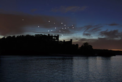
career as an artist, Melissa explores what is and what is absent. She wanted to apply this study to the island, the castle, and pieces of the castle that no longer exist. She envisioned that points of light could glow above pieces of the castle that are now missing. Melissa is the most recent architect on this island - an architect of light and space - stars - that shine above the castle as a new constellation starting at dusk of every evening.

Even though Melissa makes art of all kinds - paint, sculpture, sound installations - this project could be the largest and most visual representation of her fascination of what is and is not in the spaces in between absence and presence. She became a director and producer of the project, working with other local artists like Niche Modern to build the lights, and worked with The New York State Office of Parks, Recreation and Historic Preservation to secure what was needed to make this project a reality for launch in June 2015.

Intrigued by her role as an artist in this project, we thought Melissa a great role model for children and adults who yearn to be artist but don't know how, or who need to give themselves permission to be their own type of artist. Melissa was kind enough to answer some questions about her captivating Constellation project in this interview with us below.


Melissa McGill, architect of the Constellation Project at Bannerman Castle on Polopel Island
Why did this idea occur to you? To build the stars?
Like so many who travel and live along the Hudson River, I’ve had a long fascination with the mysterious castle ruin and this island.  As I investigated its history and re-imagined its present, I was moved to create a project that continues my work exploring the space between absence and presence, bringing to light the overlooked, hidden, or lost aspects of architecture, found objects, and places. The sculptural poles of Constellation reference the lines of the castle ruin and through the star-like points of lights hovering above, a new constellation is created conceptually connecting our world with others. I look up at the stars for inspiration, for a sense of reality, to remember how small we are in the universe, and to feel how we are all one under these stars.

I wanted to ask you about your type of artistic medium, and how as an artist, you are directing a project and don't necessarily touch everything that is being made by hand. I loved seeing the pictures of the glass blowers making the stars. So for budding artists, it's an example to show them and their parents the different types of artistry that can exist. So I suppose the question is - in this project, are you an artist who is not physically making things, but you are leading the construction of an idea?
My work involves an interdisciplinary process, primarily incorporating drawing, sculpture, and sound. I make a lot of work in my studio. When ideas require specific expertise that I don't have, I work with others who have that expertise so the work may be realized. Regarding the glassblowing...While I do have some experience with glass blowing and have made other work in blown glass, the globes that house the LED's had to be very high quality and luckily Niche Modern here in Beacon specializes in exactly what I needed. They were amazing to work with and they very generously donated the globes for the project. A project the size of Constellation requires a lot of expert experience in many areas…fabricators, architects, engineers, installers, lighting designers…the list goes on. Almost every single person on the Constellation team lives in this area and I am involved in every step of the process.

What did you need to go through legally to get this done, and how long did that take?
Pollepel Island with the Bannerman Castle ruin is located in the Hudson Highlands State Park so I worked closely with NYSOPRHP (New York State Office of Parks Recreation and Historic Preservation throughout Constellation's 3 year process). Constellation had a full environmental assessment through NY State, a NY State Archaeological Review, and NYSOPRHP executed a permit.

Financially, did this come together through different grants and/or donations? How did you approach and accomplish that?
I raised the funding independently through many channels- by crowdfunding, applying for grants and being persistent. A number of wonderful supporters taught me a lot about fundraising. Fractured Atlas is my fiscal sponsor and this is a non-profit public art work and so all donations are tax- deductible. I am so deeply grateful to Constellation's generous supporters. They have helped transform this project from a dream to reality. I still have quite a bit to raise to close the funding gap to cover installation and production. It's an on-going process and donations of support are appreciated!

The project is set to launch this weekend, June 28th. Boat tours will be offered to those curious enough for an up-close experience of this new magical constellation. Watch the video about the project here or follow along on the project's Facebook page for news and updates.


Constellation from Melissa McGill on Vimeo.